Monday, July 31, 2017

Princess Louisa Inlet and Beyond


After clearing Harmony Islands and removing the bark wrapped around the propeller shaft, we headed north up Jervis Inlet.  It's a lengthy haul up Jervis, divided into three long reaches, Prince of Wales, Princess Royal, and Queens.  Fortunately an up-channel breeze arrived and we rolled out the Genoa, continuing with the engine to keep up our speed.  We needed to maintain at least four knots if we were to make it the 35 miles to the rapids at the time the current turned slack.  Later, when we noticed that our speed over ground was in excess of five knots with the engine at idle we knew we could dispense with the diesel altogether.  By the time we entered Princess Royal reach the wind had built and rollers were lifting the stern of the boat.  I noticed that Tula had popped her headsail as well and was speeding along the north shore. It is usual in these reaches for the wind to blow up-channel in the afternoon, bringing white caps later in the day.  After a raucous ride, we arrived at the entry to Princess Louisa Inlet 90 minutes ahead of schedule.


With too much time and no lack of wind, we tacked back and forth waiting for the rapids to calm. By slack we had four sailboats and about six power boats hovering at the entrance. One power boat decided to jump the gun and go through before the ebb turned to flood. We watched the boat struggling against the current.  Horsepower won out the the rest of the power vessels followed suit leaving the four sailboats to linger a little longer.  Sailboats are a little under powered and their deep keel can get swept to one side or the other if a stiff current grabs it. It's good to wait.

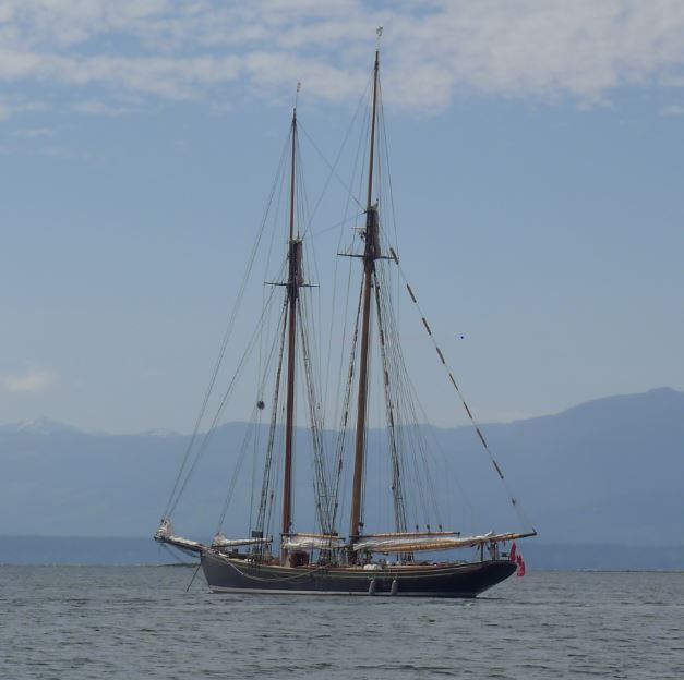
Tula with power boat hot on her tail.. through Malibu rapids

Finally at the stroke of 16:11 a single hander in a ketch headed through the now placid rapids.  A sloop followed and Tula fell in line behind with Traveler bringing up the rear.  A power boat named Papa De'eau had just arrived up Queens Reach and approached under speed, looking like it was going to cut off our friends on Tula.  Scott Tobiason hailed the boat and asked what his intentions were. "I'm going through Malibu."  Scott (in a very professional manner) explained that he was already in the approach and we should transit one at a time.  Papa De'eau came back with " But I'm doing 10 knots!"  Scott came back with, "I'm doing four knots and the speed here in the rapids is posted not to exceed five."  There was a few more terse words exchanged but Tula kept her position and old Papa De'eau had to follow.  Of course, he cut in front of Traveler and we followed through, last in line. 


Once through I hailed Tula and suggested that we put up the sails and take our time coasting the few miles up Princess Louisa Inlet, giving us time to forget the rudeness and making our entry a pleasant one.  Now that the current had turned, everyone who was going through the rapids had already done so and the power boats who raced to the anchorage and dock were claiming the good spots.  That's how it always goes.  The boats with big engines hurry to the destinations and take what's available.  The sailboats come in later and take what's left.  I cannot count the times we've entered a breakwater or anchorage and had powerboats zip around us to beat us in. I just stand off and wait for them to get out of the way. 

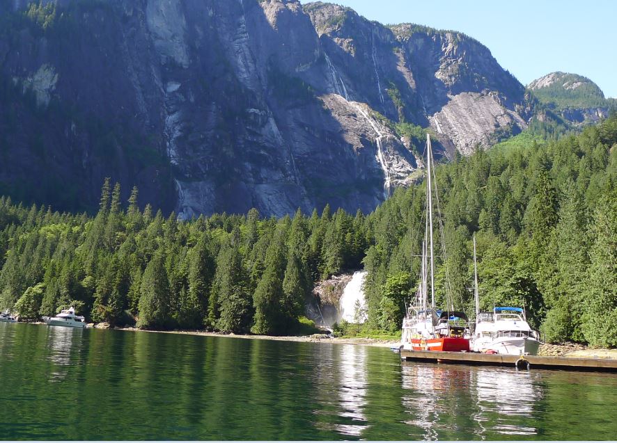
Chatterbox Falls with public dock


At the head of Princess Louisa Inlet is Chatterbox Falls, a lovely cascade of water.  All around the head of the Inlet are waterfalls, running thousands of feet from the towering heights of the fjord. I counted ten visible from where we drifted while Tula went ahead and scouted the dock for open spots.  We felt lucky as we got the call on the radio from them to come on in and that there was room on the inside near the ramp.  "You can raft up to Tula or try to squeeze into a 45 foot space."  Our boat is 44 feet long overall so it would be a squeeze.  We slowly coasted in, nosed her bow into the dock and used reverse and a little prop walk to slip into the dock with inches to spare.  Across the dock from us sat the towering Papa De'eau, blocking our view of the bay and the falls. 


That's Ok.  We had a great group dinner with Scott, Karen, Alan, and Dick and the next day we hiked and kayaked and had a grand old time.  The first morning a few boats left and we got Traveler and Tula relocated to the outer part of the dock with nice views all around. Day three we motored out of Louisa and arrived at the rapids at 10:37 to again be the last boat to transit. Entering Queens Reach we were glad to see the stern waves of the half dozen boats racing away into the distance.  We had Jervis to ourselves for the rest of the day except for when we met the next batch of visitors about halfway through Princess Royal Reach. First the plodding sailboats, then an hour later, the racing powerboats.  All of us visitors live by the timing of Malibu rapids.


Unfortunately we had the up-channel wind again and so had to motor into wind and waves all day, arriving finally at Ballet Bay within Blind Bay and an easy anchorage for the night.  Tula left the next morning with a northwest wind to help them sail south back to Pender Harbor.  As our next destination was to the north, we decided to take a lay day and wait for the northwest wind to lie down a little.


Tenedos Bay
Texada Island is a crazy 28 miles long and it seems to take forever to leave it astern. In light winds we motored north and were finally able to sail for a while just off Harwood and Savory Islands. We passed the town of Lund and found a stern tie anchorage in the Copeland Islands.  The next day the little channel between the Copelands and Malaspina Peninsula was quite active with boats, everyone motoring north to get into the famous cruising grounds of Desolation Sound. I seemed like all the boats in Canada were converging on this one spot!  We choose to duck into Tenedos Bay and enjoyed a down wind genaker run to the head of the bay.  It took some doing but we found a spot to stern tie and then took the dinghy over to the creek for a hike and a swim in the lake.


Our Desolation Sound anchorage

The next day we rounded the corner and sailed by Prideaux Haven, a fabulous place but much too popular.  I could see on our AIS that there were numerous big yachts in there and by the chatter on the VHF could tell it was quite crowded so we gave it a pass.  We did enter Laura Bay but seeing the 20 boats in there, we left as soon as possible.  Around the corner we finally found a spot to ourselves in the lee of Roffey Island.  The 15 foot tide was quite alarming as the next morning we found ourselves down in a little hole surrounded with heaps of drying oysters.  Carefully, we made our exit, sailing west to Squrrel Cove where we found a large anchorage of constant depth and no stern ties necessary. 


Responding to a hail on the VHF, we were surprised to find Tammy and Dan on their Union Polaris cutter Anjuli. We knew them from our cruising time in Mexico and were surprised to see them up here in the Northwest.  They had just shipped their boat to BC on a cargo ship and had picked it up in Nanaimo the same day we happened to be there. Small world.  We enjoyed the anchorage, the provisioning, and the company of our friends, staying in quiet Squirrel Cove for two nights.  On the way across Lewis Channel Connie calls me up deck.  "See that fishing boat?  Is that a log boom back there behind it?"  "Holy Cow! Don't go behind that boat... It's a tug, towing a log raft!"

Refuge Cove

We visited Refuge Cove and topped off the diesel tanks and visited the store at the docks.  There we met Joy and Jeff on Folie a Deux, friends from Olympia and the South Sound Sailing Society.

Another chance meeting!  From Refuge Cove we went around the corner and found a nice stern tie right at the mouth of the falls at Teakerne Arm. There we hiked to the lake above the falls. Connie did some world class dives off the cliff and we met another couple from Olympia, Geb and Shannon on S/V Marie.  It's amazing to run into so many people you know up here....


We are seeing oysters all around but also see the signs saying not to eat the oysters, but then I see a guy on the dock with a bucket full of oysters hanging in the water.  I ask the guy, "What about the signs?"  He's telling me that anywhere near harbors or populated areas they put the signs just to be safe.  Evidently the problem isn't red tide, it's a fecal chloroform problem.  He recommended we find the oysters in less populated areas.  Open one up and put a little on your lip to test for red tide. Now we are on the hunt again for oysters

Traveler anchored at Teakerne Arm near the falls
And now we are in the land of fewer boats, less people, and more wilderness.  The run north from Teakerne Arm was against the wind (a typical northwesterly) and we were short on time to catch the flat water at Yuculta rapids at precisely 17:18 ... on the 22nd.  Turns out I'd lost a day somewhere and it was the 23rd, with flat water at 18:08 so we cooled our heels floating just south of the rapids for an hour.  But soon we arrived at Big Bay and the Stuart Island Community Dock.  Everything here happens at the turn of the tide with Yuculta rapids just around the corner to the south and Gillard Passage and Dent rapids just north.  As we approached the dock, two more sailboats came in, SawLeeah and Kwinnum from Vancouver.  Cocktail hour happened and we made Canadian friends.  Everyone is so friendly here. We talked, drank some wine, and Connie played a couple of songs.  Now it's almost 10:00 PM, still light in the sky, and the local folks in small boats are drinking and smoking on the dock and grilling fresh caught fish.
 
Big Bay, Stuart Island Community Dock

I'll be hiking up to the little store in a minute where rumor has it there is WiFi. And we've got showers included with the moorage here. It will be the first shower in 25 days. Can you imagine?  Of course we take deck baths, sink baths, spit baths, and swims in lakes, but a shower... with hot water... what a luxury!

Tomorrow at noon we run a couple more rapids and proceed further north in search of bears on the beach, crabs in the trap, and shrimps on the barbecue
.   


Friday, July 21, 2017

Gerrans Bay to Harmony Islands

Poor little tug.  A submerged wreck is nearby.
When we left you last we were creeping slowly into Gerrans Bay where we spied a red buoy that itself was submerged by a few feet.  We coasted by and looking down into the depths we could see the fore deck of a sunken ship about 8 feet down. Some poor soul had lost his boat to wind, weather, or neglect.  Upon anchoring, Connie gave me the pumping fist signal meaning "The anchor is dug in well."  We readied the dinghy for a trip across the bay.


-------------------------------------------------
At this time I might talk a little about our anchoring routine. Our preferred method is to locate our spot, do a circle watching the depth sounder to assure enough depth so we don't run aground when we swing the other way at low tide.  After we have the spot, I approach head to wind and bring the boat to a complete stop, watching the water beside me to see when we've stopped moving.  Then I begin to back up and signal Connie up on the bow to drop the anchor. 


By this time she knows how deep the water is so she can calculate how much rode to let out.  The anchor swims to the bottom and as I back down Connie lets out chain so that it lies on the bottom in a fairly strait line.  Once we have at least a three to one scope (Say in 30 feet of water we have 90 feet out) Connie will tighten the clamp on the windless and put her hand on the chain to feel what is happening underwater.  As the boat goes back, the anchor chain tightens and hopefully the anchor will dig in. Connie might hold up her hand in a stop signal and I'll put the boat in neutral and let her drift backwards.  Then if the anchor chain goes bar hard Connie will give me the happy fist-pumping signal that means "It's cocktail time!"


When it comes time to up anchor we have some signals that work well for us.  Up on the bow, Connie holds her arm out to one side so I can see it through the wind screen.  She might motion forward with her fingers or give me the "just a little bit" gesture.  Palm back is stop.


When bringing the chain on board, I drive the boat and follow the chain (as per Connie's signals) as it lies on the bottom.  Connie will point one way or the other and that's the way I'll point the boat.  It's better to drive the boat up to the anchor location instead of making the windless do all the work to pull the boat.  When we've come up right above the anchor I'll creep forward slowly. Because Connie knows the depth and the markings on the chain tell her how much we have out she can easily tell when we are directly above the anchor and when it's time to break it out of the bottom.  If the windless slows down and the chain strains, then Connie knows it's stuck pretty well.  In order not to stress the windless I ease forward and Connie brings in the chain until it's bar hard.  Then on her signal, I'll power forward and this usually will lever the anchor out of the mud or sand. Once she's broke free Connie gives me the scooping back and forth hand motion to tell me it's off the bottom. As the anchor comes up, I hold the boat steady in the water, trying to keep her head to the wind.  Once the anchor is aboard Connie circles her arm in the air and points to our exit from the bay and off we go, happy as clams. 


So you see, most of our anchoring is done without a word being said and certainly without anybody yelling.  If there is a problem, I'll put the boat in neutral and walk forward to have a quiet conversation. Or Connie will walk back to the cockpit to discuss it with me. In this instance I've positioned Connie on the bow with me at the wheel.  However, we switch positions often so we're both familiar with the bow and stern duties.


We seem to see lots of folks on boats who have stressful anchoring experiences or who just anchor badly. It's a fun cocktail activity to sit and watch the fleet come in and anchor.  The later in the day, the less selection of good anchoring spots is available.  The most common bad practice we see is a boat drop the anchor while moving forward at speed.  Now if you are anchoring under sail, that is a valid method, but not for motoring.  We also see folks drop the anchor, pile a lot of chain right on top of it, and call it good.  That anchor is not set and possibly it will be fouled in the chain.  And we hear a lot of yelling, one person screaming something and the other yelling "What?" 


And of course there are the professionals who wear headsets so they can have a nice little conversation as they go about their anchoring duties on different ends of the boat.  With Connie and I, we use hand signals.

S/V Tula stern tie operation at Harmony Islands

Lately, we've been doing a lot of stern ties, where you drop and set an anchor then take a line to shore in the dinghy, bring it around a tree or through a ring, then back to the stern of the boat, suspending the vessel between the shore and the anchor.  That way the pull on the anchor is always in one direction and there is room for many boats to do the same alongside. Again, it is a fun cocktail activity to get your stern tie in early, then sit back and watch the fun begin.

-------------------------------------------


Back in Pender Harbor, using the public float at Madeira Park we offloaded our garbage and recyclables and walked up the hill to the liquor store, pharmacy, and Thriftway grocery.  While Connie shopped for produce I stood guard over the cart full of wine outside the store.  I ducked inside and asked, "Do you have internet here? I haven't checked my mail in a week."  The young man at the service counter said, "Sorry, we don't have public internet."  His coworker coldly studied me for a moment then told me the office password. "What's it matter? Go ahead and use it." Canadians are so nice, aren't they? 

Heading up Jervis Inlet with a strong breeze behind us
From Pender Harbor we sailed up Agamemnon Channel to Green Bay.  Making our way to the head of the bay we circled the small rocky anchorage. There was a little house on the rocky shore with a small dock upon which a young lady was nude sunbathing. Upon our arrival she rushed up the trail to the house.  Sorry about that! We circled around watching the depth sounder. Rocks abounded left and right.  The wind was building and we were on a lee shore.  Connie gave me that look that means she is uncomfortable with the location so we motored back out of the bay and continued up Agamemnon Channel under sail, taking advantage of the afternoon up-channel winds. 


We crossed Jervis Inlet and found the Harmony Islands where it took us three tries in the windy conditions to get the anchor set mid channel in 50 feet.  Luckily there were numerous iron rings set into the shoreline rock face and it was comparatively easy to run the stern tie to shore. Actually, it was really easy because there was a guy rowing about in a dinghy and he took my line ashore for me while I held Traveler stern to shore in reverse gear.  We settled in and watched the show as a big 45 footer struggled to get his 300 feet of line strung from boat to shore and back when the boat was 200 feet from the ring.  I finally jumped into the dinghy and gave the skipper a hand. Turn about fair play, eh?


The following day the Tobiasons arrived in Tula, their Catalina 36 and we were all set to buddy boat up Jervis.


The next day while heading out, we heard and felt a change in the propulsion and a little bit of thumping noise.  Neutral, reverse, forward.  Still some sound.  Neutral, reverse, forward, less sound but still something there.  I began to worry, thinking about propeller shaft, cutlass bearing, the propeller itself....  In forward gear the shaft was vibrating causing the dripless bearing to spew salt water into the bilge.  We thought the worst but hoped it was just a little something caught in the propeller.


OK, I'll do it.
I hailed the Tobiasons on Tula to see if they had their Go-Pro underwater camera aboard.  They came by, rafted up, and Scott Tobiason attached the camera to a pole and took a movie of the propeller and rudder.  Sure enough, there was something brown wrapped around the prop shaft.  Daylight was burning, as John Wayne would say, and we didn't have too much time to waste if we were going to make it to Malibu rapids at slack.  Connie was having wrist problems and I didn't feel comfortable trying to free dive the prop.  We talked about setting up the compressor and using the hookah so I could go down, thinking that would take us an hour or so to complete. I looked at Scott Tobiason with a raised eyebrow and he finally said, "OK, I'll jump in there and do it." 


Scott's father Dick set his timer.  Exactly 8 minutes later the propeller was cleared of a strip of bark and we were casting off and heading north to keep our appointment with Malibu rapids.  A strong wind built pushing us up channel and giving us an exhilarating, head sail only, ride up the famous Jervis Inlet.
Alan and Scott and the offending piece of bark
............posted from Squirrel Cove on Cortez Island. 
                                                                            More to come as soon as I get time to write it..........

Monday, July 10, 2017

To the Sunshine Coast

The cavernous holds of Traveler were chock full of seafood when we sailed north out of Pirate's Cove on the 27th of June, timing it such as to approach Dodd Narrows at a slack ebb current predicted for an hour past noon.  Our GPS track showed that we'd been here southbound last September 9th 2016 on our way from Ketchikan to Olympia. That time we caught the slack flood and rode the ebb, trying to make good time south as we were in boogie mode.  This time I could see a few sailboats up ahead hovering as they waited for the current to turn the other way. When we arrived at the pass the time was right, and we all poured through the channel, which is about 175 feet wide at it's narrowest point.

Because there is a dogleg at the north end of the pass, boats must transit carefully so as to not be surprised by oncoming traffic.  Some people announce on VHF radio channel 16 that they are coming through. However, since there are normally only two slack times per daylight hours, when those times occur during busy summer months, a parade of boats will be coming through. No need to broadcast guys, everyone is doing it.  We crept through slowly, keeping to the right and hoping that nothing huge would come around the corner when we did. Nothing huge did.

I'd been talking to a power boat operator the day before who witnessed what he called "road rage" in Dodd Narrows.  A few powerboats were coming through at slack when right at the tightest point they came upon a small fleet of sailboats, all trying to sail through without the benefit of their auxilery engines.  The powerboats, being "give way" vessels, had to dodge the sailboats who were "stand on" vessels by maritime law.  Channel 16 erupted with road rage as power yelled at sail. 

When I heard that story I remarked politely to the power boater, "Seems like those sailboats could have just motored through like everyone else.  Maybe they were in a race."  And of course that's what was happening, a normal occurrence there at Dodd Narrows.  To myself I chuckled and thought of the times I'd been going through narrow passages when a powerboat roared through tossing me about in an unsafe way.  Can you say, "Just desserts?"
In Nanaimo we anchored two nights and tied at the dock two nights with the Nanaimo Yacht Club. Canadians, what friendly people. They invited us to a party and gave us hamburgers, hot dogs and cheap local beer or wine. We left Nanaimo on Canada Day, avoiding zippy little boats, jet skis and the fireworks display that was to take place right there in New Castle marine park where we'd anchored.  Everyone wondered why we gave up our precious spot...

Exiting through Departure Bay and seeing big wind and waves in the Strait, we hauled up a reefed main, rolled out the jib, and pushed out into the bigger water.  With the wind and waves on the stern, we sailed north.  The Strait of Georgia gets up some big blocky rollers, we call it chop, when the wind blows across that long stretch of fetch, not unlike the Golfo de California. We were battened down well and stayed on deck so as not to get seasick; such it was as we galloped north.  Traveler was happy to have wind in her sails and to get playfully tossed about. 

Eventually we rounded the corner and found Northwest Bay with a sheltered anchorage for the night.  I fired some flares (half of them failed) to celebrate Canada Day and we listened to the people ashore on the beach celebrating around their camp fires by singing Oh Canada.

The next day was similar weather and sea state.  By early afternoon the rollers were about three foot high and we were happy to again turn the corner, this time into Deep Bay where we found Hal and Kathy on their summer boat, Ms Kathryn.  This couple has two boats, one in Mexico (Airborne)and one in Canada (Miss Kathryn) and that's where they call home.


Summer home, Miss Kathryn

Hal and Kathy arranged reciprocal moorage for us there at the Deep Bay Yacht Club dock and we spent three nice days with them there, sharing meals and tall tales.  Deep bay is deep, the marina being in about 50 feet of water and just the right depth for me to catch crabs off the back of the boat. Could't be any handier.  We took the opportunity of having Hal's 18 year old nephew, a lifeguard and recent graduate, available for labor, and he cleaned the bottom of the boat for us.

Boat bottom cleaning team: Boss #1, Boss #2, and Diver


I'm amazed that after 15 months there was very little growth and no barnacles!  That's what happens when you keep the boat moving and then put her in cold Puget Sound waters.


Oysters a plenty!
North of Deep Bay we found Henry Bay on Denman Island for a quiet night.  The next morning we took the dinghy ashore at low tide and harvested 20 beautiful oysters before raising anchor on the mother ship and threading the needle through Comox channel to go around the corner to Hornby Island and the popular anchorage and beach at Tribune Bay where boys chased girls in bikinis, and kids dug in the sand. We joined the crowd for a warm afternoon of walking the beach, swimming, and drinking beer sitting in the sand.  


I was worried about the weather forecast as it predicted 10 to 15 knots from the SE rising to 15 to 25 knots early in the morning.  Tribune Bay opens to the southeast so I had good reason to be concerned. The night was calm. The early morning was flat as a pancake. The big gaff schooner, Pacific Grace had anchored a quarter mile off our bow and we watched her three boats row ashore, each young bosn steering with an oar, the bow person calling out the cadance to the four oarspersons.  Each of the three boats beached, then got carried up the tide line.  The 30 crew then set about playing an active game of frisby.  About 09:30 the wind started softly from the SE.  A few boats up-anchored and left.  At 10:00 the wind became brisk and a short chop came up.  A few more boats left.  At 10:30 I looked at the small sailboat next to us and the skipper on the bow was having difficulty hanging on while trying to pull the anchor up.  Time for us to go! 


Tribune Bay
Connie road the bow like a cowgirl, running the windless to pull the anchor on board as I struggled to keep the bow into the wind.  Finally we got her secure and, full throttle, headed out of the bay right into the teeth of a 20 knot blast with three foot building waves. After an hour of upwind progress I climbed onto the cabin top and raised the main, putting in three reefs.  Then I brought up the little staysail and Connie turned to port bringing her under sail and pointed at Lasqueti Island, eight miles to the north.

Crossing the Strait of Georgia
 
We had closed all the hatches and put everything away down below.  With the reduced sail she still made 4.5 knots which was plenty for us as the waves were rolling in on the starboard side and sending spray onto the boat.  As we neared Lasqueti the wind veered from a beam reach onto the nose so we had to crack off and head toward Texada Island.  Once we found that shore we tacked our way SE up into Sabine Channel to finally find refuge between Lasqueti and Jedediah Island. We'd sailed 25 miles, taking about six hours to do so.  If we'd been a powerboat, we could have motored a straight line and made the trip in 15 miles. But hey, we are a sailboat and should sail whenever there is wind. Just think what we saved in diesel costs!


Pacific Grace

 As we came across the strait I saw on the AIS that Pacific Grace had also left Tribune Bay as was making her way south.  Just think of the team building experience those kids had launching those boats in the surf and pulling hard to get back to the mother ship.


Lasqueti and Texada Islands are right in the middle of the Strait of Georgia and serve as stepping stones for boats transiting from Vancouver Island to the mainland.  Between Lasqueti and Texada are a group of little islands that seem remote, but aren't. They have excellent anchorages.  We found our spot and spent a quiet night.  The next day I set out a shrimp trap in 200 feet of water and a crab trap in 50 feet then we went to work on projects.  The day before when Connie was stowing the staysail halyard she inadvertantly pulled the wrong end and it got lost inside the mast.  Now somebody had to go up the mast to drop a weighted line down inside the mast so we could re-run the halyard.  Normally the person named "somebody" is me.  However, there is an old saying "She who 'skies' the halyard, climbs the mast".  Nuts up the mast.JPG CB up the mast.JPG

It took a few tries but finally I was able to retrieve the line from inside the mast as Connie fed it in from the top. When I looked up I could see her way up there above the deck clenching the mast between her thighs like a vice. I'm darn proud of my wife for facing her fear of heights and scampering right up that mast.  And what a relief to have the halyard back in service!

While Connie continued work on her new song, I went back out in the dinghy to search for the shrimp trap and at long length found it just where I left it.  Empty.  Then the crab trap. Empty. With my head hanging low I stowed my traps, floats, and lines while my wife fried up some fresh oysters for dinner.  Then while bread was baking in the oven, we watched one of the new videos we'd scored from Hal and Kathy. Thanks, you two. Such nice people. They are Canadian, you know.

Lonely anchorage on Lasqueti
From Lasqueti we sailed across Malaspina Channel in a light southeast wind, flipping the jib out to the port side and the main out to the starboard side in a maneuver called "wing on wing". We sailed into Pender Harbor on the sunshine coast of British Columbia.  Oh my Dog, what a bunch of boats they had in there!  We tried to squeeze into Garden Bay but unless we'd be comfortable with a scope of 3 to 1 we'd not fit.  Then we tried near Wellborne Cove and fished up a bunch of rocks with the anchor.. grind, rumble, rumble.  I spied a Hans Christian 38 off to the south in Gerrans Bay and thought, "There is a kindred soul.  He'll know where to anchor".  We coasted by, engine off, and had a conversation with the Vancouver sailor who directed us around the corner where there was lots of room and a submerged wreck to avoid. 

While boiling two pots of water I hung various pieces of fabric around the cockpit creating a bit of privacy then got naked and had a wonderful bath/shower/cleanup there in the cockpit.  Connie followed suit and then we're both squeaky clean.  Me shaved. Fresh clothing on, ready for tomorrow when we go ashore to seek out the following:

Gasoline  ( for the dinghy )
Hydrogen Peroxide ( for a splinter in somebody's finger )
Prescription refill ( my rosacia is acting up )
Internet ( to post this blog entry )
Wine ( always )
Trash ( depositing, not acquiring )
Panko ( for all that seafood stuff we are catching )
Kale or Chard
Broccoli or Califlower
1/2 and 1/2 ( for my dear Connie's tea)

I look at the GPS trail and see that we sailed right by here ten months ago, making good time to cross the Strait of Georgia, bound for Nanaimo.  That was a different time, a different plan altogether.  What we did then in two days we now do in the opposite direction in five.  Taking life at ease. Meandering.

Pender Harbor, Gerrans Bay on the Sunshine Coast